Trails at a Glance
|
| Flume Trail Shuttle |
Length (1 way) - 13.5 miles |
Elevation gain - 1,100' |
Difficulty - Intermediate |
Other Users - Hikers, Official vehicles on access roads |
| |
| Flume Trail Loop |
Length - 23.1 miles |
Elevation gain - 3,000' |
Difficulty - Expert |
Other Users - Hikers, Official vehicles on access roads |
| |
| Tahoe Meadows - Spooner Lake |
Length (1 way) - 20.6 miles |
Elevation gain - 1,450' |
Difficulty - Expert |
Other Users - Hikers, Official vehicles on access roads |
| |
| Chris Tucker Trail |
Length (1 way) - 2.5 miles |
Elevation Gain - 250' |
Difficulty - Intermediate/Expert |
Other Users - Hikers |
| |
| Directions |
Best to just look at the map. |
| |
| Nearby Bike Shops |
Flume Trail Bike Shop - Spooner Lake parking lot.
Book a Flume Trail shuttle with Wanna Ride Tahoe.
all figures are approximate |
|
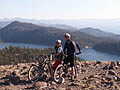
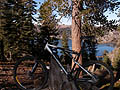
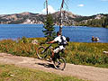
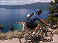
The Flume Trail
The Flume Trail is one of Lake Tahoe's most well known mountain biking trails. There is only one Flume Trail, but there are a number of trails in the area besides the Flume Trail. We'll try to cover them all.
Trail Map
The Flume Trail
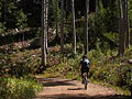
The actual Flume Trail starts at Marlette Lake and runs until you reach Tunnel Creek Road. While on the Flume Trail you will see pieces of the actual flume from time to time. That is, if you can take your eyes off the trail. It does get narrow for the first timers. If your doing the standard car shuttle, leaving from Spooner Lake and coming out on Tunnel Chute Road, this is technically an easy to moderate ride. The uphill to Marlette Lake is strenuous, and will turn into a hike a bike for some. In dry summer conditions, Tunnel Creek Road can get a little bit sketchy if the sand gets too soft.
The Rim Trail
Not everyone wants to shuttle this run as a one way trip, and fortunately, there are many other options. It can be looped by turning right at Tunnel Creek Road rather than left. Then you meet the Tahoe Rim Trail and follow it back to North Canyon Road Canyon. The Rim Trail section, unlike the even graded Flume Trail, does have some ups and downs as well as some technical sections. Note: The map lists the 5.5 mile section from Spooner to Snow Valley Peak as no bikes. When you get to Sunflower Hill Road, there is a sign there that says no bikes any further on the Rim Trail, so I guess that 2.6 mile section is out too, and you must turn right.
The Chris Tucker Trail (Chutney)
This is an alternative to the North Canyon Trail to get down from Marlette Lake. However, it does not end up at the Spooner Lake parking area. It leaves the mian trail (road) from the flats above Marlette Lake right before the long downhill to Spooner Lake. After a brief climb to clear the ridge around the lake, it's a smooth, rather steep 2,000' vertical descent down to Highway 28. The is a nice option especially for those coming from Tahoe Meadows.
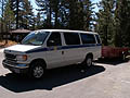
The Shuttle
Flume Trail Mountain Bikes offers a shuttle that runs regularly from May through November weather permitting. Rather than use two cars, take the shuttle. Do not try and ride back along Highway 28. It's uphill, there is lots of traffic, and no shoulder. The shuttle also offers trips to the Tahoe Rim Trailhead at Tahoe Meadows. Biking is allowed on this section of trail on even numbered days. On odd numbered days you can charter the shuttle to head to the Kingsbury North trailhead. Both these rides end at Spooner Lake if your car is there. Each of these shuttles has different prices, which can be found here. If you start your ride at Spooner Lake you must pay something. There is a $2.00 per person for entering the park on bike. Cars are $6.00 for up to four people. There are probably ways to get around it, but that's the money that pays for trail upkeep. If you enter by car, your ticket also gets you into Sand Harbor and/or Cave Rock.
Click on the images below to enter the gallery.
|


