Trails at a Glance
|
| Corral Trail |
Length (loop) - 3.5 miles |
Elevation change - 600' |
Difficulty - Intermediate |
Other Users - Moto-x, 4 wheelers |
| |
| Sidewinder Trail |
Length - 1 mile |
Elevation change - 300' |
Difficulty - Intermediate |
Other Users - Moto-x, 4 wheelers |
| |
| Incense Cedar Trail |
Length - 2 miles |
Elevation Change - 200' |
Difficulty - Intermediate |
Other Users - Moto-x, 4 wheelers |
| |
| Armstrong Connector |
Length (loop)- 3 miles |
Elevation Change - 680' |
Difficulty - Intermediate |
Other Users - :-) |
| |
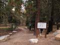
| Directions |
The bottom of the trailhead is on Fountain Place Road (Oneidas). You'll see a gated dirt road and a small dirt parking area just after you cross the first creek on the way up. Park here and start riding up or leave a car here for a shuttle. The top of the Corral Loop is about 2 miles up with a decent size paved parking. If your heading for the top of the Armstrong Connector, or heading up to Armstrong Pass and the Rim Trail, drive to the end of the road.
Oneidas Street is located off Pioneer Trail about 1 mile from the intersection with Highway 50 in Meyers. |
| |
| Nearby Bike Shops |
Wattabike - Next to Roadrunner Gas Station in Meyers.
Sierra Ski and Cycle Works - Highway 50 just east of Safeway in South Lake Tahoe.
all figures are approximate |
|
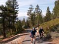
Corral Loop and More
The Corral Loop is probably the most popular trail on the South Shore in terms of everyday use. It's perfect for an afternoon workout and it leaves from very close to Pioneer Trail. But now, it's not just the Corral Loop any more. There are other options and it's really becoming more of a trail network. There is the Sidewinder Trail, the Incense Cedar Trail, a new Armstrong Pass Trail. All of this connects with the Powerline Trail for more options.
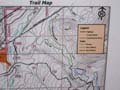
Trail Map
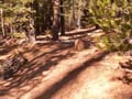
Corral Loop
This is the original trail around which the rest of the Fountain Place trails were built. The trail starts at just over 7,000 feet and runs for about 2 miles until it meets up with powerline road.
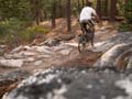
The top part is more technical and earns the most difficult moniker from the forest service. In reality, it is probably only intermediate when compared with other Tahoe trails. There are several small rock garden sections, but they are fairly easy. After a small creek crossing (bridge) the slope becomes much more gentle and the run earns an 'easiest' title. The bottom part, while nearly flat, is typically sugar sand, which adds to the difficulty.
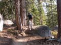
Sidewinder
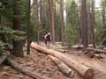
After about 100 yards on Corral Trail there is a fork to the right. This is the appropriately named Sidewinder Trail. This is a series of high banked berms with some mildly technical riding thrown in as well. There are also a number optional log rides including a 50 footer towards the bottom. The trail meets back up with Corral just above the creek crossing and the top of Incense Cedar trail.
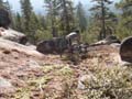
Incense Cedar Trail
This is a mellow, flowy trail that starts off with a short climb. Afterwards, it's pretty flowy across varied terrain with one very shirt climb. It drops you off on the Powerline Road with several climbs and downhils before connecting back with the bottom of Corrail Loop.
Armstrong Connector
This new trail (10/07) connects the top of Fountain Place Road with the top of Corral Loop, about midway down the road. The Forest Service has done some excellent work here. The trail traverses through large boulder sections, and while an itermediate trail, has plenty of terrain options to satisfy most expert riders.
Click on the images below to enter the gallery.

|


